Log in
All resources
Create a design
2,977 Free Artworks of City Map
bibliothèque nationale de france
maps of paris from bibliothèque nationale de france
turgot map of paris, bibliothèque nationale de france
beschreibung der städt der welt - braun & hogenberg - btv1b52512111k
baroque
fonds ancely - bibliothèque municipale de toulouse - maps
steel engraving print
bibliothèques de toulouse
victor levasseur - maps of france
raymond bonheur
civitates orbis terrarum. urbium praecipuarum totius mundi. liber quartus
maps of harlingen by braun & hogenberg
civitates orbis terrarum. urbium praecipuarum totius mundi. liber quartus
maps of malmö by braun & hogenberg
1572 maps of africa
1570s maps of egypt
victor levasseur - maps of france
engravings by nicolas mignard
coats of arms of cities in ardèche
victor levasseur - maps of france
coats of arms of cities in drôme
jean étienne championnet
19th-century maps of loire (department)
coats of arms of cities in loire
munich in the 17th century
baroque
old maps of schaffhausen
munot in art
düsseldorf in the 1800s
old maps of düsseldorf
bibliothèque municipale de reims, rès. g 152
old maps of abbeville
civitates orbis terrarum. urbium praecipuarum totius mundi. liber quartus
old maps of ancient rome (city)
eran laor cartographic collection
jean-claude richard de saint-non
maps of amersfoort by braun & hogenberg
maps by willem and johannes blaeu
typus orbis terrarum
1570 maps of asia
brooklyn bridge – city hall (irt lexington avenue line)
city hall (irt lexington avenue line)
eran laor cartographic collection
michael burghers
eran laor cartographic collection
pierre mortier
charts and maps of the royal museums greenwich
1777 maps of new york (state)
maps by willem and johannes blaeu
1635 maps of africa
map of maastricht by willem and johannes blaeu (1649)
markt (maastricht)
coats of arms of cities in lot-et-garonne
victor levasseur - maps of france
turgot map of paris, bibliothèque nationale de france
maps of paris from bibliothèque nationale de france
turgot map of paris, bibliothèque nationale de france
maps of paris from bibliothèque nationale de france
turgot map of paris, bibliothèque nationale de france
maps of paris from bibliothèque nationale de france
turgot map of paris, bibliothèque nationale de france
maps of paris from bibliothèque nationale de france
turgot map of paris, bibliothèque nationale de france
maps of paris from bibliothèque nationale de france
turgot map of paris, bibliothèque nationale de france
maps of paris from bibliothèque nationale de france
turgot map of paris, bibliothèque nationale de france
maps of paris from bibliothèque nationale de france
turgot map of paris, bibliothèque nationale de france
maps of paris from bibliothèque nationale de france
turgot map of paris, bibliothèque nationale de france
maps of paris from bibliothèque nationale de france
turgot map of paris, bibliothèque nationale de france
maps of paris from bibliothèque nationale de france
turgot map of paris, bibliothèque nationale de france
maps of paris from bibliothèque nationale de france
turgot map of paris, bibliothèque nationale de france
maps of paris from bibliothèque nationale de france
turgot map of paris, bibliothèque nationale de france
maps of paris from bibliothèque nationale de france
turgot map of paris, bibliothèque nationale de france
maps of paris from bibliothèque nationale de france
turgot map of paris, bibliothèque nationale de france
maps of paris from bibliothèque nationale de france
turgot map of paris, bibliothèque nationale de france
maps of paris from bibliothèque nationale de france
turgot map of paris, bibliothèque nationale de france
maps of paris from bibliothèque nationale de france
turgot map of paris, bibliothèque nationale de france
maps of paris from bibliothèque nationale de france
turgot map of paris, bibliothèque nationale de france
maps of paris from bibliothèque nationale de france
turgot map of paris, bibliothèque nationale de france
maps of paris from bibliothèque nationale de france
old maps of edinburgh
history of edinburgh
old maps of dutch brazil
recife in the 1660s
victor levasseur - maps of the world
1850s maps of oceania
kanonenteich (leipzig)
adolf eltzner
frankfurt (oder) city bridge before 1819
oder river in frankfurt (oder)
beschreibung der städt der welt - braun & hogenberg - btv1b52512111k
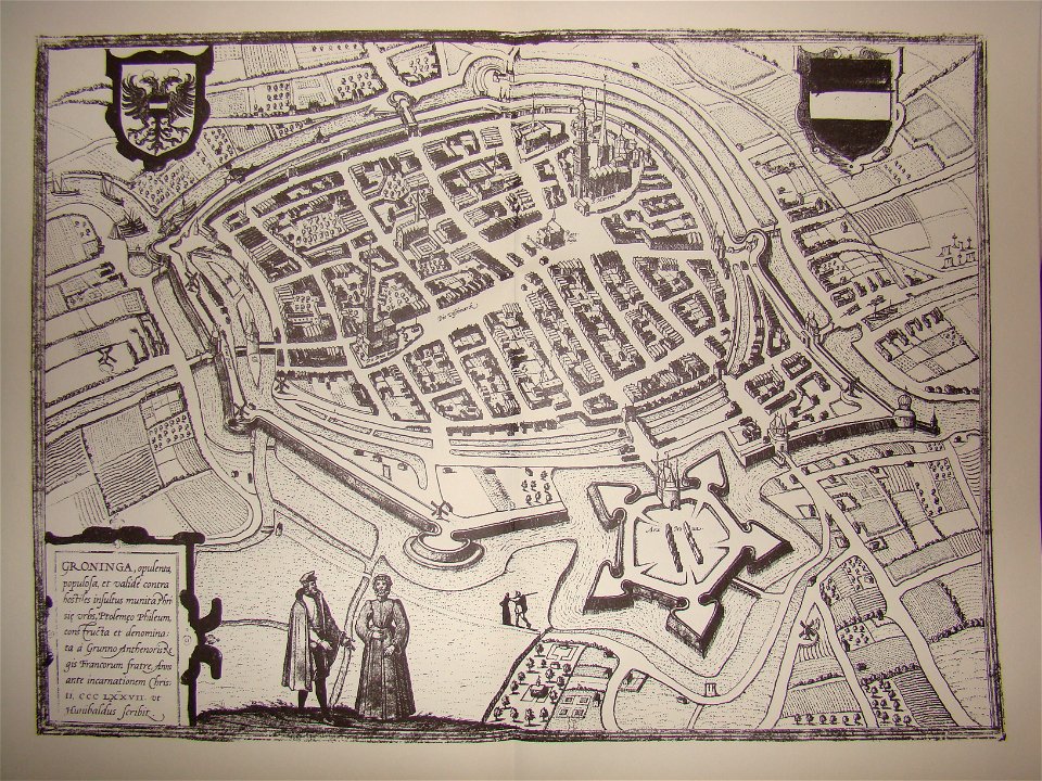
maps of groningen by braun & hogenberg
beschreibung der städt der welt - braun & hogenberg - btv1b52512111k
maps of mainz by braun & hogenberg
beschreibung der städt der welt - braun & hogenberg - btv1b52512111k
maps of heidelberg by braun & hogenberg
beschreibung der städt der welt - braun & hogenberg - btv1b52512111k
maps of dunkerque by braun & hogenberg
beschreibung der städt der welt - braun & hogenberg - btv1b52512111k
maps of nîmes by braun & hogenberg
maps by jakob van der schley
history of hormuz island
maps by willem and johannes blaeu
old maps of gorinchem
maps by willem and johannes blaeu
old maps of dordrecht
eran laor cartographic collection
louis-joseph mondhare
old maps of ghent by jacques horenbault
1619 maps
maps of philippsburg city walls
old maps of philippsburg
landais & oberthur
maps from gallica
perris & browne maps of manhattan published in 1857
neoclassicism
lutetia parisiorum urbs, toto orbe celeberrima notissimaque caput regni franciæ by sebastian münster
maps of paris from bibliothèque nationale de france
lutetia parisiorum urbs, toto orbe celeberrima notissimaque caput regni franciæ by sebastian münster
maps of paris from bibliothèque nationale de france
18th-century maps of catalonia
daniel de la feuille
old maps of the sinai peninsula
1870s maps of palestine
maps of the west-indische compagnie
1665
maps of trenton, new jersey
gregory anthony perdicaris
palatinatus rheni (merian)
baroque
palatinatus rheni (merian)
baroque
palatinatus rheni (merian)
baroque
palatinatus rheni (merian)
baroque
maps of tournai city walls
old maps of tournai
maps of goa by braun & hogenberg
old goa
maps by george w. boynton
1840s maps of boston
old maps of lima
joseph mulder
maps of chimay by braun & hogenberg
maps of chimay city walls
old maps of salvador (bahia)
jacob van meurs
maps of groningen by braun & hogenberg
sconces in the netherlands
gemeente atlas van nederland - overijssel
netherlands in the 1860s
parts of old maps of berlin
maps of berlin-mitte
maps of aire-sur-la-lys city walls
old maps of aire-sur-la-lys
maps by matthäus merian
baroque
map of bruges by marcus gheeraerts (i)
1562 maps
maps from traité de la police, bibliothèque nationale de france
first map of paris from traité de la police
johannes nessel
1656 maps
maps of arras by braun & hogenberg
maps of arras city walls
new york and brooklyn, with jersey city and hoboken water front
maps in the library of congress
new york and brooklyn, with jersey city and hoboken water front
maps in the library of congress
maps from university of amsterdam special collections
atlas der neederlanden
maps of paris from the barry lawrence ruderman antique maps inc.
key sheet of the turgot map of paris
beschreibung der städt der welt - braun & hogenberg - btv1b52512111k
maps of tunis by braun & hogenberg
beschreibung der städt der welt - braun & hogenberg - btv1b52512111k
maps of 's-hertogenbosch by braun & hogenberg
beschreibung der städt der welt - braun & hogenberg - btv1b52512111k
maps of münster (westfalen) by braun & hogenberg
beschreibung der städt der welt - braun & hogenberg - btv1b52512111k
panoramic maps of seville by braun & hogenberg
royal city in polish–lithuanian commonwealth
maps of lviv by braun & hogenberg
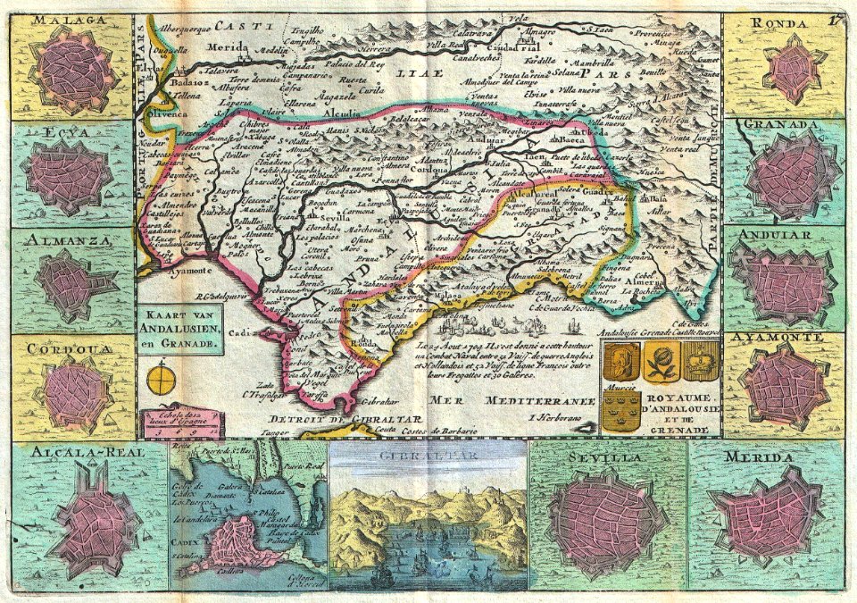
18th-century maps of andalusia
daniel de la feuille
old maps of china in harvard map collection
1749 maps of asia
maps in the british museum
jan claesz ten hoorn
maps of bergamo city walls
maps in the museo correr
maps of oudenaarde city walls
old maps of oudenaarde
engravings of topographia palatinatus rheni
baroque
601 - 700 of 2,977
Next page
/ 30